>Translated with www.DeepL.com/Translator
(>Pictures at the bottom!)
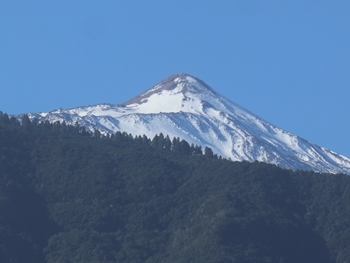
Gran Canaria is not the largest island of the Canary archipelago; besides Fuerteventura, Tenerife is also much larger and, compared to Fuerteventura, very mountainous. The mountains run through the middle of the island and rise to a high plateau of over 2000 metres, where a few million years ago the Pico del Teide grew to 3718 metres in a massive eruption and is now the highest mountain in Spain. Snow, storms and wintry conditions are nothing unusual around Teide and the summit climb can be closed for weeks.
Surrounding the Teide National Park is the “Parque Natural de Corona Forestal”, which lies like a collar around the Teide and covers a very large area of the island with a pine forest. Immediately following and to the north-east is the wild area of the “Parque Rural de Anaga”.
The north and north-west coasts are favoured with a lot of humidity and allow the vegetation to flourish in all its varieties. It is also the area where most people on the island have settled and cultivate other agricultural products besides bananas.
Actually, everything on Tenerife is steep to very steep; from the highest elevations, the slopes often reach down to the sea. The roads wind along the slopes, climb steeply uphill or fall almost in the fall line towards the sea.
The many tourist facilities are to be found on the south-west as well as the south coast, where people enjoy the sun on the few kilometres of beach or take advantage of the many other offers of the tourist industry. So it is not surprising that next to abandoned banana plantations there are hotel complexes as if from a thousand and one nights, followed by countless ruined buildings and…. a bit of rubbish everywhere! Read More

