>Translated with www.DeepL.com/Translator
(>Pictures at the bottom!)
…as we all know, the way is the goal of the journey
Our jeep was fully packed again, the last repairs done and we were already heading north out of Flagstaff. As we left relatively late, we looked for a place to stay for the following night south of Sunset Crater – a national monument – on a playground for big boys. In these vast areas, all off-roaders, ATV and OHV riders are legally allowed to let off steam in the volcanic sand. Crazy these Yanks! The following day we also enjoyed the ride around various volcanic cones and soon reached the Navajo and Hobi Indian Reservation.
Whether we were travelling legally or illegally on the Indian reservation, we didn’t know and still don’t know. On certain roads there are signs alerting the user to a permit, on other roads there was nothing to be found. But we wanted to cross the huge reservation to Monument Valley, which is owned by the Navajo tribe.
Although we had already driven around the countless towers of Monuments Valley 4 years ago, it was again a wonderful experience. Back then we experienced it in winter, now we were in early summer and the majority of the plants, which were brown at that time, were now in bloom. We had to accept the fact that at this time of year – just before the big holiday season for Americans – things were busy and vehicles were following each other in dusty intervals.
After Monument Valley, we continued to roam the Indian reservation and thus commuted back and forth between Arizona, Utah, New Mexico and Colorado. In Colorado itself, we visited monuments where the indigenous people had built real stone houses and immediately reminded me of the Middle Ages. In terms of time, both the European castles and the stone houses of the indigenous people of North America are roughly identical. We had already visited various places where the indigenous people lived in stone houses, which somewhat challenged our idea of the wild indigenous people with their tepees.
The southwest of Colorado, in addition to the Indian reservations, is designated as a National Forest over large areas and allowed us great opportunities for movement far away from the well-developed roads. Actually, I (Tom) wanted to fulfil my wish and drive over the Black Bear Pass at almost 4’000 m above sea level. But last winter’s heavy snowfall made this wish come to nothing; the long trail traverses were still covered by a thick layer of snow.
In the same valley, we tried again at a pass to the south. We reached the Ohpir Pass, but a large snow cornice prevented us from continuing westwards. Whether we would have made the following traverse without slipping would probably have been more a matter of luck than driving ability. Chantal discovered another passage on our electronic map that could have led us over the ridge into the valley to the west. We were already scrambling up again with our jeep to dizzying heights, where a cold wind blew around our ears even in the warm summer time. Even up there, our jeep could not go any further; there was too much snow between the rocky outcrop and the forest.
After a week of wandering around in the forests and mountain flanks, we gave up and dutifully followed the tar belt over the Red Mountain Pass into the next valley. Up to Ouray, we were also accompanied by the American past and the search for the precious metal, where many old mines still remind us of that time. In those days, people thought that everything was possible to find great fortune somewhere underground.
Again we turned off and followed the road in a north-westerly direction; Moab was the next destination on our wish list. But the mountains in the Manti-La Sal National Forest – we were already in Utah – again forced us for several retreats, as there was a lot of snow everywhere on the northern slopes. Perhaps the green meadows with the huge herds of cattle misled us. In a few hairpin bends above the lush meadows, we were already back at 3,000 metres, so snow and slush were not uncommon on shady slopes. But around Moab you don’t necessarily have to drive over the highest elevations; even at lower altitudes there is a lot that an adventurer is looking for. We too found our adventurous ways through narrow canyons and rock towers down to the Colorado River.
Moab itself is a true mecca for outdoor enthusiasts and off-roaders. Wanted or unwanted; in the centre moved the craziest petrol-guzzling off-road vehicles that you don’t get to see anywhere else anymore. We wanted to settle down at a club campsite for the next few days, as we needed to do laundry and take care of our cars and our own bodies. But when the receptionist told us the price, we turned around shaking our heads and left the place immediately. She wanted 111 US dollars per night for a simple pitch! No, not with us! We were already on our way out into the next forest, where the pitch cost a ridiculous $10 and the body and clothes washing was done in the nearby creek.
West of Moab lies Bridge Canyon, where probably few tourists stray. The way up is stony and demands a lot from the vehicle as well as the driver. So we experienced another wonderful night in a lonely canyon, where only a few coyotes disturbed our night’s rest. The drive back down to the Colorado River was another highlight and only for strong nerves.
After this quiet time away from the tourist crowds, it was almost obligatory for us to visit Arches National Park. Undeterred, we drove to the entrance gate, where the cashier immediately turned us away because we couldn’t show a reservation. Somewhat awkwardly, we turned around and looked for a hotspot where we could sign in to the running hour window and start the long round trip through the Arches N.P.. After the first kilometres it was already clear to us why everyone wants to come here; the landscape is breathtaking and our cameras were in continuous operation. After every bend or terrain transition, there was a new “wow”. The respective parking spaces were overcrowded and everyone wanted to get up to the respective sandstone arches. But, as soon as the road was more than 500 metres long, I (Tom) found myself alone on the road and could enjoy the landscape alone. At the very end of the developed park road, Chantal found another way back via a gravel road. We didn’t know at the turn-off that this road really demanded the climbing skills of our jeep and were surprised at the first climbs in no-man’s land, but I (Tom) had fun on every incline and decline.
After so much tourist hype, we both had enough of queuing and inflated prices. We left Moab behind us and headed for somewhat quieter areas. At the National Monument of the Natural Bridges or the Capitol Reef N.P. we could enjoy the unique natural wonders almost alone. Although the campsites at the respective hotspots were fully booked, the surrounding National Forests always offered us a good opportunity to find a great place to spend the night.
Across wide plains where cattle and dairy farming is practised, we reached the Uinta Mountains and the ultimate winter sports resort Park City, one of the largest ski parks in North America. As far as ski resorts go, we Swiss are probably in the best company, but here everything is just a little bit bigger and we could really imagine the winter hustle and bustle in the streets of this noble winter sports resort.
Salt Lake City, on the salt lake of the same name, was unable to cast much of a spell on us; the urban hustle and bustle was too much for us, despite the local summer holidays, and we already fled westwards out into the wide world. We drove around a large military restricted area and soon reached the border to Nevada, where in the plain of Bonneville (salt lake) still today some kind of records are set with all kinds of cars.
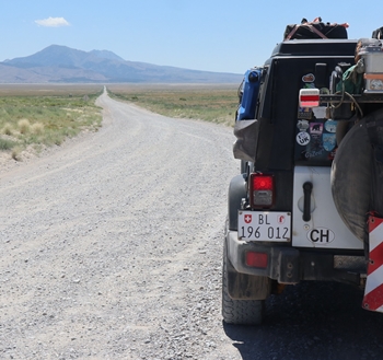
In Nevada, we followed the loneliest road in North America in a westerly direction and were suddenly surprised to see the sign “Pony Express” appear again and again. Apparently, we were on the way of the former pioneers who travelled here through this lonely and barren landscape in a westerly direction towards their future. On subsequent research, we also discovered that we were already on this route from Salt Lake City, which also served as an important courier route for earlier messengers.
The individual sections in northern Nevada were very monotonous and kilometre after kilometre dragged on. In addition to the boring driving, the daytime temperatures always climbed towards 40°C. To escape this heat, we were already on the lookout for the next elevation in the afternoon, where the evening temperatures were usually more pleasant for camping at night.
After the gold mining town of Berlin, it was not far to the Californian border. In Benton we finally reached the state that is a dream destination for many. At the customs check – California has strict food controls on vegetables, fruit and meat – we explained to the official, somewhat shyly, that we had our dinner with us and didn’t want to throw it away. With a wink, he let us go on our way to the Golden State. Whew, our dinner was saved!
At the next petrol station we wanted to fill a few gallons of diesel into our almost empty tank. My European credit card didn’t work at the pump and the clerk refused to pay cash; she was off duty now and the computer programme had already shut down. There was an open petrol station in 51 miles! Well, welcome to California.
We continued our journey with an almost empty tank, hoping that there really was diesel in Lee Vining. The 20 litres in the spare can gave us the courage to continue our journey. After all, we want to get over the mountains to Yosemite N.P. and on to the Rubicon Trail near Lake Tahoe as soon as possible.
Chantal & Tom/End of July 2023


>Translated with www.DeepL.com/Translator